Technology and area

Mapping | Infra | Land | Utility

Integrating drone data into GIS for accurate mapping, monitoring, and analysis of landscapes and assets.

About Us

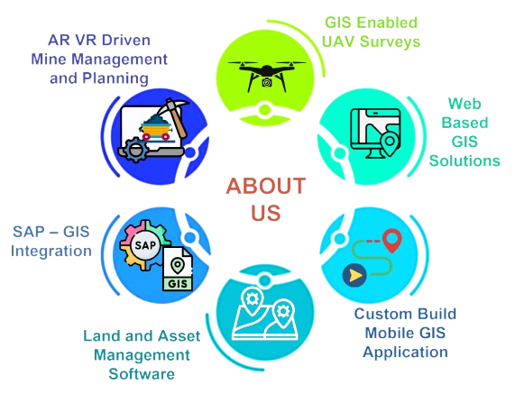
Welcome to LGEOM, your avant-garde hub for cutting-edge GIS-enabled solutions fused seamlessly with advanced IT capabilities. At LGEOM, we redefine the boundaries of innovation by integrating state-of-the-art Geographic Information System (GIS) technologies with the latest in IT infrastructure.

Our seasoned team of experts specializes in crafting bespoke solutions tailored to your precise requirements, leveraging the dynamic synergy between geospatial data analytics and advanced IT architectures. From intricate spatial analysis and precision mapping services to bespoke GIS applications and next-gen IT infrastructure development, we empower businesses, organizations, and governments to navigate the complex landscape of modern data-driven decision-making with confidence.

At LGEOM, we don't just offer solutions; we architect experiences that propel your success into the future. Discover the possibilities with LGEOM, where cutting-edge GIS meets the forefront of IT innovation.

Services

Integrated GIS Web Development

LGEOM offers a comprehensive suite of web development and IT consulting services designed to drive digital transformation and achieve business objectives.

Read More

Web Based Asset Management

Elevate Your Operations with ArcGIS-Enabled Web-Based Asset Management Unlock the full potential of your enterprise with ArcGIS-enabled web-based asset management solutions

Read More

GIS-Enabled UAV Surveys for Precision Mapping

We specialize in GIS-based surveys tailored for the precise mapping and collection of underground and aboveground assets, with a particular emphasis on pipeline infrastructure.

Read More

Hydrogeological Investigations

Our focus centers on conducting customized hydrogeological investigations for industries, aimed at minimizing their impact on groundwater.

Read More

solution

Land Acqustion Management System

Land Acquisition Management System (LAMS): Redefining land procurement with unparalleled precision and efficiency.

Read More

GIS Mine Management System

Our system empowers mining operations to achieve optimal safety and efficiency. It tracks key operational...

Read More

Offline Navigation
System

This user-friendly system simplifies navigation within gated communities. It provides optimized routes and vital...

Read More

SAP-GIS Integration

Imagine revolutionizing your enterprise resource planning ecosystem by integrating it with the sophisticated spatial analytics intelligence...

Read More

Cients really love us

Our Partner